Game of Thrones Maps
Every Continent, Kingdom, City & Hidden Location — The Known World, Mapped in Full
The Game of Thrones world contains two primary continents — Westeros (home of the Seven Kingdoms, ~3,000 miles north to south) and Essos (the larger eastern continent, stretching from the Free Cities to the Shadow Lands of Asshai). Together they form The Known World, the full fictional geography of George R. R. Martin’s A Song of Ice and Fire series.
The Three Essential Maps
Before exploring individual regions, orient yourself with the full Known World, then drill into each continent.
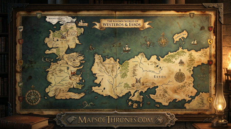
The Known World Map
The complete geographic canvas of the Game of Thrones universe — two continents, one Narrow Sea, and thousands of years of history compressed into a single map. Every war, every journey, every exile plotted to scale.
Westeros — Full Continent Map
From The Wall in the frozen north to the sun-scorched deserts of Dorne — 3,000 miles of war, politics, and geography. The Seven Kingdoms, the Great Houses, and every castle that changed hands during the series.
Essos — The Eastern Continent
The vast eastern continent — home to the Free Cities, the Dothraki Sea, Slaver’s Bay, Old Valyria, and the unknown eastern extremes. Larger than Westeros and far less unified, Essos shaped Daenerys Targaryen’s entire journey.
Every Game of Thrones Map by Region
Drill into any kingdom, region, or territory — with character ties, key events, and geographic context.
The North & Beyond the Wall
Winterfell, Castle Black, the 700-foot Wall, the Last Hearth, and the frozen Lands of Always Winter. The largest region in Westeros by landmass.
King’s Landing — Capital Map
The Red Keep, the Great Sept of Baelor, Fleabottom, the Street of Steel. A detailed street-level map of Westeros’s most important city.
Dragonstone — Targaryen Seat
The volcanic island fortress of House Targaryen, gateway to Blackwater Bay. Origin point of Aegon’s Conquest and Daenerys’s return to Westeros.
Dorne — Southern Kingdom
Desert sands, the Red Mountains, and Sunspear overlooking the Summer Sea. The only kingdom that resisted Aegon the Conqueror — and survived to tell it.
The Reach & Highgarden
The most fertile land in Westeros — Highgarden, Oldtown, and the breadbasket that fed the realm. Until Cersei Lannister burned it all.
The Vale of Arryn
The Eyrie perched at 20,000 feet, the Mountains of the Moon, and the most naturally defensible region in all Westeros. No army has ever breached it.
The Iron Islands
Rocky archipelago. Harsh seas. The Ironborn live by the motto “We Do Not Sow.” Pyke, Great Wyk, Old Wyk, Harlaw — all mapped in detail.
Free Cities of Essos
Nine mercantile republics on Essos’s western coast — Braavos, Pentos, Myr, Tyrosh, Lys, Volantis, Qohor, Norvos, and Lorath. Each independent, each dangerous.
The Dothraki Sea
An ocean of grass stretching across central Essos, ruled by nomadic khals and their khalasar. No city stands here — the Dothraki are the city.
Slaver’s Bay — Dragon’s Bay
Astapor, Yunkai, Meereen — the slave cities that Daenerys liberated and ruled. Now renamed Dragon’s Bay, this region transformed the entire series.
Beyond the Wall
The Haunted Forest, the Fist of the First Men, Craster’s Keep, Hardhome, and the Land of Always Winter. Everything the Night’s Watch was built to contain.
Seven Kingdoms at a Glance
Key geographic and political facts for each major region of Westeros — optimized for fast reference.
| Kingdom / Region | Ruling House | Capital | Distance from King’s Landing | Key Feature |
|---|---|---|---|---|
| The North | House Stark | Winterfell | ~500 miles north | Largest region by landmass; borders The Wall |
| The Vale | House Arryn | The Eyrie | ~300 miles east | Mountain fortress at 20,000 feet; never conquered |
| The Riverlands | House Tully | Riverrun | Midway N–S | Most contested land; site of the Red Wedding |
| The Iron Islands | House Greyjoy | Pyke | ~200 mi offshore (west) | Rocky archipelago; seafaring Ironborn culture |
| The Westerlands | House Lannister | Casterly Rock | ~400 miles west | Richest lands; gold mines beneath Casterly Rock |
| The Reach | House Tyrell | Highgarden | ~300 miles southwest | Most fertile land; Westeros’s breadbasket |
| The Stormlands | House Baratheon | Storm’s End | ~200 miles southeast | Coastal cliffs; storms of the Narrow Sea |
| Dorne | House Martell | Sunspear | ~600 miles south | Only kingdom never conquered by Aegon Targaryen |
| King’s Landing | The Iron Throne | The Red Keep | — (the capital) | Population ~500k; founded by Aegon I Targaryen |
Game of Thrones Map FAQs
The most common questions about the geography of the Known World, answered in full.